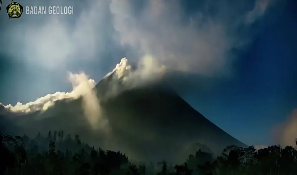
KABARJAWA – Mount Merapi again showed its volcanic activity. Throughout the week (8/17/2025), the Investigation and Development of Geological Disaster Technology (BPPTKG) recorded seven incandescent lava falls upstream of Kali SAT and Kali Putih with a maximum slide distance reaching 2,000 meters.
Observation data compiled by BPPTKG, Ngadiyo and Yulianto officers, recording Merapi activities in the early Monday morning, August 18, 2025 at 00.00 to 06.00 WIB.
During that time span, the visual mountain was clearly visible even though occasionally covered with thin to moderate fog. Weak white pressure crater smoke is monitored thick with a height of about 50 meters above the top of the crater.
Seismic activity of Mount Merapi
Note of seismicity shows that volcanic activity is quite intensive. BPPTKG records 25 times the earthquake with an amplitude of 2-21 mm and a duration of 101-203 seconds.
In addition, detected 18 hybrid earthquakes or a large phase with a amplitude of 2-18 mm, SP 0.2-10.9 seconds, and a duration of 7-15 seconds. One far -tectonic earthquake also occurred with an amplitude of 11 mm, SP time 23.88 seconds, and a duration of 129 seconds.
The data shows that the supply of magma in the body of Merapi is still ongoing. This condition has the potential to trigger incandescent lava and clouds in the radius of potential danger.
Meteorological conditions and the status of Mount Merapi
The weather in the observation period was relatively varied. BPPTKG noted that the sky around Merapi looked bright, cloudy, cloudy. The wind blows weakly to the east and west. The air temperature is in the range of 16.4-20 degrees Celsius, humidity 93.4-99 percent, and air pressure 874-918 mmHg.
This meteorological condition supports visual activity so that officers can observe the incandescent lava fall from the monitoring post.
Until now, Mount Merapi is still at level III or standby. BPPTKG reminded people to remain aware of the potential dangers of lava and clouds.
Potential dangers of the southern sector-Daya Daya include the Boyong River as far as a maximum of 5 km, as well as the Bedog, Krasak, and Bebeng rivers as far as a maximum of 7 km.
In the southeast sector, the potential danger includes the Woro River as far as a maximum of 3 km and the Gendol River as far as a maximum of 5 km.
In addition, if an explosive eruption occurs, the volcanic material can reach a radius of up to 3 km from the peak. BPPTKG also reminded the public to anticipate the potential of rain lava and interference due to volcanic ash.
Appeal for the community
BPPTKG explicitly asked the public not to carry out any activities in the potential danger area. Residents are also asked to always be aware of the possibility of clouds of falling flooding, especially when it rains around the slopes of Merapi.
If mountain activity shows a significant increase, the BPPTKG will immediately review the status of Merapi activity.
The community is expected to follow all official information from Kesdm, Geological Agency, and PVMBG so as not to be trapped in unclear news.
Mount Merapi with an altitude of 2,968 meters above sea level stretches in the Sleman (DIY), Magelang, Boyolali, and Klaten (Central Java) regions.
Until now, the most active mountain in Indonesia continues to emit its volcanic activity, as if reminding humans to always be vigilant in facing the possibility of threats from nature.
Game Center
Game News
Review Film
Rumus Matematika
Anime Batch
Berita Terkini
Berita Terkini
Berita Terkini
Berita Terkini
review anime